Severn Valley Railway
A small group of Malvern U3A Geology group spent an enjoyable day on Saturday l8th June, on and off the Severn Valley Railway. Margaret Rodway from the Hereford and Worcester Earth Heritage Trust was our leader for the day.
Much of the route we followed was based on the Earth Heritage Trust trail guide produced for the Severn Valley Railway. This can be purchased from Herefordshire and Worcestershire Earth Heritage Trust; Geological Records Centre; University of Worcester; Henwick Grove; Worcester WR2 6AJ (01905 855184) ; cost around £2. In addition, the EHT have produced a factsheet for Stanley Quarry.
Click here for
Visit Report
We arrived at Kidderminster Station in good time to look at the dolorite and basalt cobbles in front of the station and across the road we looked at building stones used in the shop fronts - amongst which were granites, sandstones, oolitic limestones and freestones, particularly sandstone faces with clear fault lines.
On board the train, a “steamer”, a bonus for those of us with multiple interests!, our journey to Bridgenorth via Bewdley, Arley, Highley, Hampton Loade and Eardington afforded us views of red sandstones in cuttings and the Permo-Triassic new red sandstone cliff near Bewdley Station. As we moved into the Severn Valley we crossed a major geological junction from dune bedded sandstone onto the harder and paler Carboniferous sandstone. We noted river terraces between Arley and Highley and the erosion of the river bank - and gravel bars, unusual as many rivers in Britain are dredged to enable navigation.
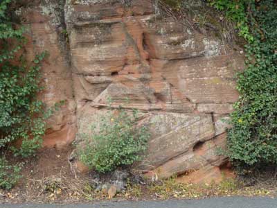
At Highley we left the train and crossed the track to the Visitor Centre; a rain downpour held us up for a few minutes, then we made a small hike to the Stanley Quarrey along a path which had been kindly cleared for us by the Railway Volunteers. The Highley sandstone here has been quarried since medieval times. Originally natural outcrops would have been exploited and in the late 1300’s transported by river and some used to build part of Worcester Cathedral. The quarry itself was not developed until the 18th century. Of the four faces of the quarry, faces 1 and 2 were easy to access. Face 1 clearly showed pick marks which created an even surface for quarrying. Vertical grooves indicated where drilling had occurred to enable two metal springs to be inserted with a wedge between, the wedge was then hammered until the block separated from the main face. At the base of this face a man-made cave had been worked, maybe a shelter for the quarrymen. On Face 2 we observed clear bedding planes and patches of bitumen on the rock surface, this may have leeched through from colliery spoil heaps on the surface, or possibly moved upwards through joints from the coal seams which were mined in this area. Faces 3 and 4 were not accessible - but from a distance and with the aid of binoculars cross bedding was seen on Face 4 and “Home Guard bullet holes” from World War 2 target practice on Face 3!
We had a lunch break at the Visitor Centre and back at Highley Station we looked at the local sandstone facings on the window sills. Back on the train heading for Bridgenorth we passed more river terracing, the flood plain and areas of landslip where we saw the elusive yellow-marked telegraph-pole which had migrated some 30 yards from the track due to the landslippage. In this area the track had been relaid several times due to this problem.
We left the train at Bridgenorth and walked down the road towards the Lower Town noticing an exposure of dune-bedded sandstone on the way. Round the next corner we were confronted by spectacular red sandstone cliffs. At about a quarter of the height of the cliffs were the marks of pitched medieval house roofs etched into the cliff-face, grooves marking chimneys were seen. A ride up the cliff railway (some of us closed our eyes) led us to a walk along the top of the cliff towards the remains of the castle. Looking from the cliff walk over the Lower Town and beyond, the river terraces and glacial moraine were evident. Ridges at the top of the opposite hill were capped with a harder conglomerate so preventing erosion.
We walked through the castle grounds and made our way back to the Station for our return journey.
Although I have probably missed out some crucial geological sightings I think we all had a really enjoyable day, and spent our journey home companionably in a decidedly “third class carriage” ! Our many thanks go to Margaret for her leadership, Jim for his usual excellent organization and to the car drivers who offered lifts.
Pictures

Looking at the cobbles outside Kidderminster station - from Rowley Rag Quarry, Dudley.

A shop front across the road from the station, greensand with obvious fault.

River terraces seen from the train, a former flood plain of the river.

Stanley Quarry face 1 showing pick marks and the cave.

Stanley Quarry face 2 showing patches of bitumen.
Dune cross bedding of Bridgenorth Sandstone at Bridgenorth.

View to the east of Bridgenorth, Bridgenorth Sandstone capped with the harder Kidderminster Conglomerate.